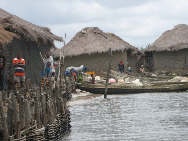
Fishing villages off the coast of Sierra Leone often can only be reached by boat. Off-loading is directly in water, as there is usually no docks. In the background, note the aerial roots of the mangroves. Credit: Sylwia Trzaska
By Elise Gout
Off the coast of West Africa’s Sierra Leone, most of the fishing villages can only be accessed by boat. These villages are separated from the mainland by several miles of dense and unrelenting mangrove forest. On arrival, the absence of a dock means the traveler must step through water and haul the boat to shore. There are no signs of previous research and development projects, unlike on the mainland, and there is “the feeling that no one ever goes” to these communities, said scientist Sylwia Trzaska. In February of last year, she and her team from the Earth Institute’s Center for International Earth Science Information Network (CIESIN) traveled to not one, but 24 of these fishing villages to conduct the very first vulnerability assessment in Sierra Leone’s coastal areas. They were joined by researchers from Fourah Bay College, Njala University, and the West Africa Biodiversity and Climate Change program (WA BiCC).
CIESIN’s research is part of a larger WA BiCC project funded by the U.S. Agency for International Development (USAID). The project has three main objectives: combat wildlife trafficking; improve coastal resilience; and reduce deforestation, degradation, and biodiversity loss. Trzaska and her team are focusing on the second of these three.
“One of the issues along the coast of Sierra Leone is very strong erosion,” said Trzaska. With their dense root systems, mangrove forests are very effective in stabilizing the soil, buffering storm surges, and protecting the coast. The forests are also, however, under great stress, as they are being cut for things like firewood and construction.
WA BiCC originally reached out to CIESIN with an interest in contributing to mangrove conservation. They wanted to know where they should plant mangroves to help combat erosion, so Trzaska’s team went on a mission to investigate where mangroves had been cut down.
However, when they visited the coastal communities of fisherman, the scope of their project changed. “These communities are very vulnerable to climate change,” Trzaska said, “mangroves or no mangroves.” She described how many people within Sierra Leone’s fishing communities live in very tight spaces just a couple of feet above the water. Though some dwellings have makeshift protections, the flood risk from storm surge and sea level rise is significant. In addition, livelihoods are at risk: as the Atlantic warms, the abundance of fish species that the communities rely on is going to change. The region also faces overfishing and illegal fishing from international companies.
 This fishing village on the coast of Sierra Leone is built on the edge of the water. The homes are made of dried mud with thatched roof, and they often flood. Here, makeshift wooden walls offer protection to the village during high tide and storms. Sea level rise and increased storm intensity will highly impact the dwellings. Credit: Sylwia Trzaska
“There is no one-size-fits-all solution,” said Trzaska. Planting mangroves will be difficult in some areas because the land is now being used for rice cultivation. In others, there are still plenty of mangroves growing. “So we wanted to know a little more about where this solution would apply, which communities are ready for this solution, and where other interventions might be more relevant.”
The team used surveys and focus groups to conduct a vulnerability assessment and to explore what solutions the communities might find beneficial. “If we want interventions to be successful, they need to match the needs of the community,” she said.
To conduct the surveys and focus groups, the team divided into four groups of twelve people who went into the field for ten days. Each group visited six communities: two where the mangroves were pristine, two where the mangroves were under a lot of pressure, and two where the mangroves were somewhere in between. Meanwhile, Trzaska checked in with the locals in a less structured setting. These kinds of informal conversations provided “complementary ideas about the environment,” she explained.
Trzaska was particularly struck by how the people she talked with were holding on to their way of life. “I’m more familiar with the Sahel, where everybody wants to leave because there are no jobs, no opportunities. It wasn’t like that in the fishing villages,” she said. “People were generally very busy and very active. There was pride in being able to make a living, even if it’s hard.”
But villagers are not aware that climate change could jeopardize their entire economy—and they haven’t prepared for it. Almost two-thirds of the respondents within the survey said that they have heard about climate change and believe that it happens, but don’t see how it applies to their cases, Trzaska explained. Thirty-seven percent of the respondents said they do not consider it a major problem for their community.
“Parts of New York might get flooded, but Wall Street is not going to collapse,” Trzaska said. “And New York City has the capacity to adapt, and planning and budgeting is already in place. The fishing villages of Sierra Leone have none of these advantages.”
At the completion of the vulnerability assessment, CIESIN submitted the report to WA BiCC to inform the project’s future activities with the villagers. “You want to help them protect their villages, protect the fish, and find some way to maintain a sustainable livelihood,” said Trzaska. But without the means to do this, one of the best strategies to improve the fishing communities’ resilience will be to diversify their livelihoods, she explained. “That begins with improving their access to information.”
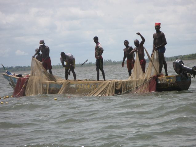
 Fishermen work together to drop a net. Fishing is a fundamental economic activity of coastal Sierra Leone, still mostly artisanal. Credit: Sylwia Trzaska
The vulnerability assessment has also motivated Trzaska’s upcoming CIESIN project, “Estimating and Mapping Off-Grid Populations.” The project combines high-resolution satellite images, volunteered geographic information, and modeling, to provide information on small settlements within mangrove areas. These settlements are in six data-poor countries in West Africa that, in addition to sharing similar landscape and livelihood characteristics, have an urgent need for locating and estimating hard-to-reach coastal populations.
“We want to make them more visible to decision makers and international development agencies,” Trzaska said. By using the project’s tool, researchers and officials will be able to estimate how many people in the mangrove areas are at risk to rising sea-levels and increasing storm intensity, and then plan specific measures to improve their resilience to climate change.
“The issues of these communities are less visible,” Trzaska said, “but the people in them are still holding on to their livelihoods, raising children, and they’re very proud of it. They’re fighting. And that makes you want to do something.”
Source link : https://news.climate.columbia.edu/2018/10/15/resiliency-sierra-leone-fishing-villages/
Author :
Publish date : 2018-10-15 07:00:00
Copyright for syndicated content belongs to the linked Source.


